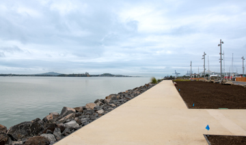
Hobsonville Point wastewater pump station
- Hobsonville Point, The Airfields
- In Progress
- Development
Hobsonville Point needs another wastewater pump station so that this thriving community can continue to grow.
This new pump station will futureproof Hobsonville Point so that capacity isn’t an issue.
About the project
More homes are planned for the growing and thriving neighbourhood of Hobsonville Point, but forecasts indicate that the capacity of the existing wastewater pump station in the area is not sufficient for the projected development in the area. Therefore, a new wastewater pump station known as Pump Station 6 (PS6) is required, to ensure existing and future residents can continue to rely on safe, reliable wastewater services.
Where will the pump station be?
The new pump station will sit on the edge of a reserve at the intersection of Bomb Point Drive and Glidepath Road. It will be fenced-off and landscaped, minimising visual impact. A rising main will be installed to connect to the existing Watercare wastewater manhole at the intersection of Hobsonville Point Road and Corsair Street.
How long will this take?
The work will happen in overlapping stages between June 2024 and early 2025. Indicative timeframes are as follows:
Stage 1
July to September 2024
Installing a rising main which takes wastewater along Glidepath Road and then Hobsonville Point Road, to the existing Watercare wastewater manhole at the intersection of Hobsonville Point Road and Corsair Street.
We are working hard to ensure any disruption is minimised while work is underway, although some disruption, such as sections of roads being closed for short periods, can be expected.
Other FAQs
What is this project?
We are building a new wastewater pump station at the intersection of Bomb Point Drive and Glidepath Road, along with installing a ‘rising main’ (a series of pipes underground that connect the system). The pipes for the rising main will be installed under Glidepath Road, then Hobsonville Point Road, connecting to the Watercare wastewater manhole at Corsair Street.
What is a wastewater pump station?
Wastewater is all the water that drains out of your sinks, washing machines and showers, and flushes down your toilet (otherwise known as sewage). It must be treated before it is released into the environment. To do this, it needs to be transported to treatment plants through a system of pipes, mains and pump stations. Wastewater pump stations help with this process by transporting wastewater, especially when it needs to move from low-lying areas into higher ground where gravity cannot help with the flow.
Why do we need a new pump station?
The existing wastewater pump station (PS3), which services Launch Bay, Catalina Bay, and the Airfields, was built in 2015 and will soon reach capacity. As Hobsonville Point continues to grow, it is crucial to ensure the wastewater network remains fit for purpose. We are investing in a new pump station to provide resilient infrastructure that will support the anticipated residential and commercial development in the area.
Why wasn’t this built years ago?
A new pump station was not previously identified as being needed. However, revised development yield forecasts indicate that PS3’s capacity is not sufficient to support the expected development in the catchment area.
How disruptive will the construction be?
Building new infrastructure comes with some disruption. In this case, installing the new rising main (underground connector pipe) will temporarily affect the road and footpath network as installation moves along the route. The installation of the rising main will be done by ‘thrusting’ the pipes underground in sections, through a series of potholes. This method minimises disruption as it avoids having to dig up the ground along the whole route.
We will work hard to minimise noise, dust and traffic disruptions as well as prioritising the safety of the community throughout works. As the staged construction programme commences, we’ll keep residents updated of specific impacts.
What does potholing involve?
Potholing is a method used to locate underground services before excavation works begin. This is an important step in ensuring the safety of workers, the public, and infrastructure itself. It involves scanning the area (e.g. road or footpath) to determine where the pipes and services are, cutting a square of the road/paving to expose the earth below, and removing a section of subsoil using a hydro-jetting truck and suction hose. Hydro-jetting eliminates the risk of accidental pipe damage that could occur by using diggers, jack hammers, or drills etc. The hole is made as deep as necessary to expose the pipe before it is measured and noted to determine the exact size and location. The hole is then backfilled, compacted and temporarily backfilled.
Once works are complete, this backfill is removed and replaced with a permanent mix equal to the road/footpath surface.
How much land is needed?
Approximately 1,000 m2 of land is needed for the wastewater pump station. As the location is in a reserve area, a replacement piece of land will be found and vested as a reserve.
What will it look like?
The pump station is largely underground and will be vented with very little visible above ground. There is a similar facility over the road from 34 Bomb Point Drive. The site is also below road level, meaning it will generally be obscured from view.
Will the location be threatened by climate change/sea levels?
The site has a 6-metre elevation above sea level. Predicated sea level rise will not affect this site.
Should it be so close to housing?
The site has a 20-metre offset to any potential housing development, which is required by Auckland Council.
Will you remove vegetation?
The project requires the removal of approximately 600m2 of vegetation to make room for the pump station. Some of this vegetation (mainly flax) will be relocated on site to create a ‘green belt’, while some will be mulched and spread on site for ground stabilisation.
When the project is completed, the area will be landscaped. This will involve replanting with similar vegetation.
Who is responsible for the project?
Watercare is usually responsible for Auckland’s wastewater infrastructure. However, there is an agreement in place between Eke Panuku (on behalf of Auckland Council) and Kāinga Ora – Homes and Communities to ensure the land in Hobsonville Point is ready for development. This is based on a legacy infrastructure funding agreement between Waitākere City Council and the Hobsonville Land Company (later renamed Homes Land Community Ltd., and now part of Kāinga Ora).
For this reason, Eke Panuku is leading the procurement, design and overseeing the delivery of the project, in close collaboration with Kāinga Ora and Watercare. CB Civil is the contractor.
Latest updates:
4 September 2024
Drilling works and rising main installation continues:
On Monday 9 September, drilling and installation of a rising main (a series of pipes connecting the system) will begin on Hobsonville Point Road, starting at the intersection with Glidepath Road and moving down to Corsair Street.
Depending on the location, we will install up to 120 metres of pipeline at a time. The works are expected to last one month, approximately.
We require road access on the eastern side of Hobsonville Point Road (the same side of the road as Hobsonville Point Primary School). This means the road will be closed, and parking unavailable in the section where we are working, reopening as we progress along the road. Where works are required in front of a driveway or accessway, we will make every effort to maintain driveway and accessway availability and will notify residents in advance, if access will be temporarily impeded.
The bus stop on the corner of De Havilland Road and Hobsonville Point Road (nearby House of Travel) will be closed during construction work hours, while the drilling and pipeline installation takes place in the immediate vicinity, but will re-open outside of work hours.
The nearest alternative bus stops are at the intersections of Isitt Road and Hobsonville Point Road or the intersection of Squadron Drive and Hobsonville Point Road. Signage will be in place at the closed bus stop to provide wayfinding. Additionally, if you have the bus stop saved on Auckland Transport’s app, it will provide updated information for users.
23 August 2024
Temporary road closure of Bomb Point Drive (Glidepath Road to Waka Moana Drive):
As a first step in the construction of the new wastewater pump station at the intersection of Bomb Point Drive and Glidepath Road, an inground retaining wall will be built over the next couple of weeks.
This will require Bomb Point Drive to be closed between Glidepath Road and Waka Moana Drive, for approximately four weeks. A detour will be in place for vehicles, but the footpath will remain open. Construction site management will be in place to keep pedestrians safe.
7 August 2024
Drilling works and rising main installation.
Starting on Monday 12 August 2024, we will begin the next phase of works involving drilling and the installation of a rising main (a series of pipes connecting the system). This work will start on Glidepath Road and progress towards Hobsonville Point Road, eventually moving down to Corsair Street.
This process will be completed in sections of pipeline up to 180 metres in length, depending on the location.
To accommodate drilling and pipeline installation, road access will be required. The section of road where work is taking place will be closed, and street parking in this area will be unavailable. We will make every effort to maintain driveway and accessway availability and will notify residents in advance, if access will be temporarily impeded.
Traffic management will remain in place to ensure the safety of road users and pedestrians.
19 July 2024
Lane closure on Hobsonville Point Road for one week.
From Monday 22 July until Friday 27 July (inclusive), one lane will be closed on Hobsonville Point Road from De Havilland Road to Corsair Street, as we continue to locate underground utility services in this area.
We will work as quickly as possible to minimise disruption. Traffic management remains in place to keep road users and pedestrians safe.
17 July 2024
Lane closure on Hobsonville Point Road as potholing progresses.
From Wednesday 17 July, for the rest of the week (the remainder of the school holidays), we will be closing one lane on Hobsonville Point Road from De Havilland Road (near Hobsonville Point Primary School) to Glidepath Road, to locate underground utility services in this area.
Traffic management remains in place to keep road users and pedestrians safe.
5 July 2024
Traffic management in place while potholing progresses.
Starting from Monday 8 July, we will continue with locating underground utility services along Glidepath Road to Hobsonville Point Road, and then to Corsair Street. These potholes will be temporarily backfilled until permanent reinstatement towards the end of the project.
We anticipate this stage to take around seven weeks total, with work happening between the hours of 7am - 5.30pm Monday to Friday. Sections of the road will be closed as we work, but we aim to keep one lane open at all times. Street parking will be unavailable, and any disruption to driveway access will be kept to a minimum.
27 June 2024
Temporary closure of Bomb Point Drive (Glidepath Road to Commanders Avenue)
The first step of the Pump Station 6 project requires identifying the location of underground utility services (like stormwater and water pipes and power lines), to help lock in the pathway for the rising main.
We do this by making several small excavation potholes to find the services. This work will start on Thursday 27 June along Bomb Point Drive between Glidepath Road and Commanders Avenue.
As a result, the road will be closed temporarily as we work in this area. We anticipate this will last about a week, with a road detour in place. The road will be open on the weekends, including the Matariki public holiday on Friday 28 June.
Footpaths will remain open throughout.